Media Only Inquiries Contact: Sam Sheronick of
Sam Sheronick Law Firm, P.C.
Phone: (319) 366-8193
(Press Release on behalf of: Sam Sheronick Law Firm, P.C.;
Cutter Law PC; Eric Ratinoff Law Corp.; Wexler Wallace LLP;
Law Offices of Russell G. Petti)
PRESS RELEASE
2016 “Flood” Proves Railroads Caused 2008 Flood in Cedar Rapids: Case Before Iowa Supreme Court
(March 16, 2017, Cedar Rapids, Iowa) A long-running class action lawsuit against railway companies related to flooding allegedly caused by the collapse of their rail bridges in Cedar Rapids, Iowa, has made its way to the Iowa Supreme Court. Plaintiffs’ Counsel in Griffioen et al. v. Union Pacific Corporation, Union Pacific Railroad Corporation, Alliant Energy Corporation, and Cedar Rapids and Iowa City Railway Company, Iowa District Court for Linn. County, LACV078694; Iowa Supreme Court Case No. 16-1462, (click 130607 Petition to see PDF of Petition) look forward to proving at trial that excessive rainfall was not the primary cause of the devastating June 2008 flood in Cedar Rapids, Iowa.
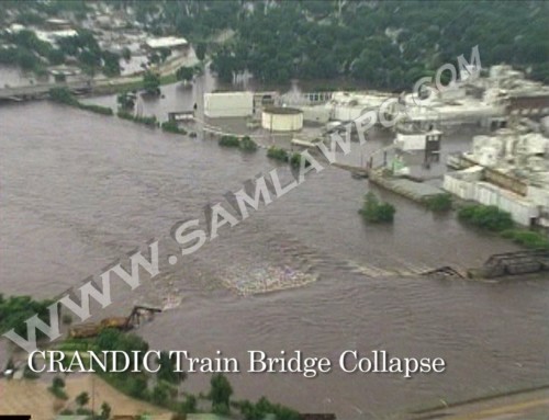
The Plaintiffs and potential class members—property owners in Cedar Rapids whose homes and businesses were lost and/or damaged in the 2008 Flood—allege that Union Pacific (“UP”) and Cedar Rapids and Iowa City Railway Company (“CRANDIC,” wholly owned by Alliant Energy Corporation) turned what would have been a minor flood into a catastrophic disaster when UP and CRANDIC parked rail cars on rail bridges that were over 100 years old, apparently in an effort to prevent the bridges from collapsing. Unfortunately, UP and CRANDIC’s ancient rail bridges across the Cedar River collapsed under the weight of the rail cars loaded with rock.
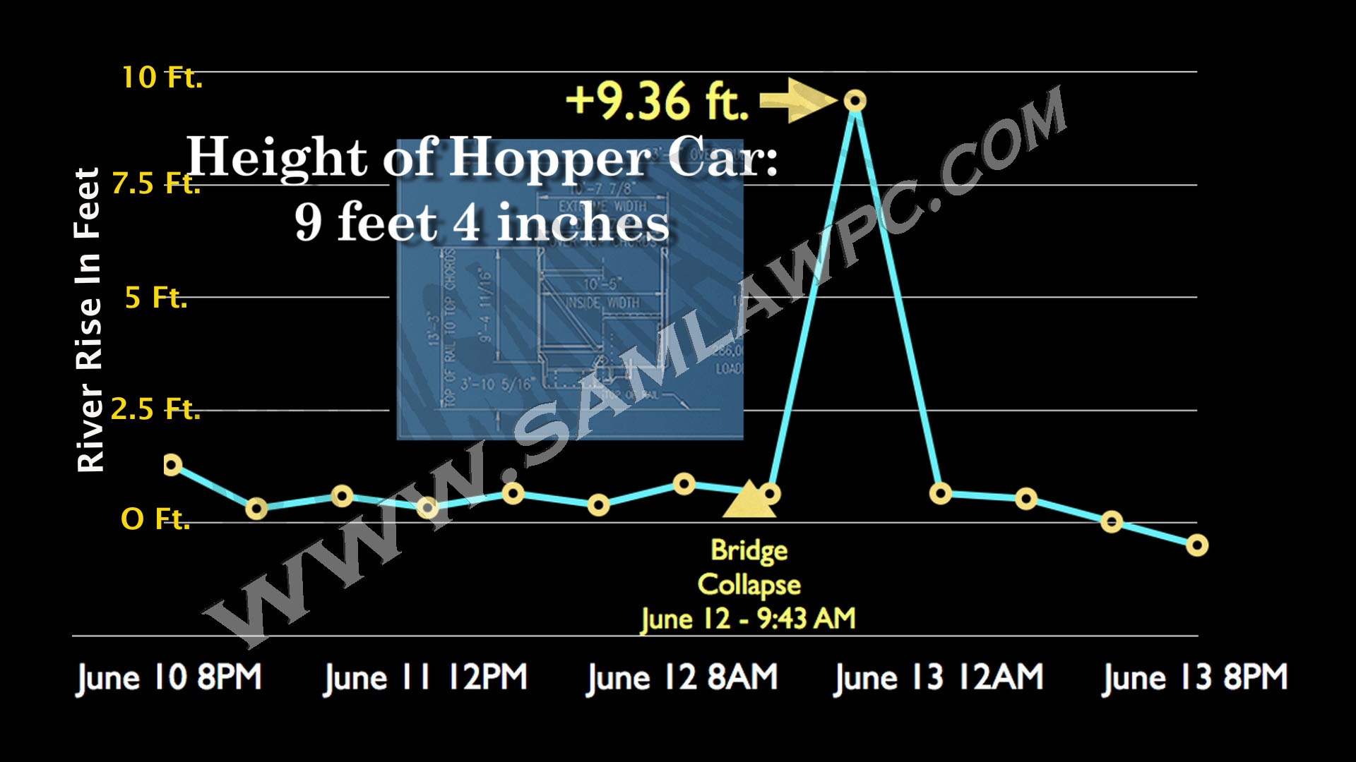
When that happened, the Plaintiffs in this case contend that the fallen bridges created functional dams, diverting water over the river banks in Cedar Rapids and overloading the storm water runoff system. When two rail bridges collapsed–one bridge holding 9.4 foot tall rail cars and the other rail bridge with solid 9.5-foot iron walls–United States Geological Survey (“USGS”) hydrograph measurements indicate that the height of the river shot up by that same amount: over nine feet.
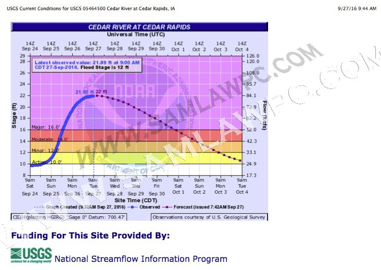
The Plaintiffs’ case is bolstered by recent events. On September 27, 2016, as noted in the USGS hydrograph below, the Cedar River crested in Cedar Rapids at 21.97 feet, which is over two feet higher than the level of the river at the time the railroads’ bridges collapsed into the river in 2008. Yet in 2016, the City of Cedar Rapids did not experience any property damage, in contrast to the 2008 Flood. The difference in 2016? The City did not allow the Defendant railroads to park their rail cars on their bridges in 2016, and no railroad bridges collapsed.
This case is now before the Iowa Supreme Court because Union Pacific and Alliant Energy/CRANDIC contend that they cannot be held liable for damages in any court of law; in other words, they enjoy total legal immunity and can never be held accountable for the damage Plaintiffs contend they caused. Plaintiffs’ Counsel are hopeful the Supreme Court will allow this case to finally proceed to trial, so that they can present the facts and the evidence that show Cedar Rapids property owners were injured by UP and CRANDIC’s actions in the 2008 Flood. “The public deserves to hear the truth about what happened,” says Co-Lead Plaintiffs’ attorney Sam Sheronick of Sam Sheronick Law Firm, P.C. “It’s time that this case gets heard on the merits so that property owners throughout Cedar Rapids can finally get their day in court.”
So what really happened in 2008 in Cedar Rapids?
*June 10, 2008: Union Pacific and Alliant Energy/CRANDIC load weighted rail cars onto their four rail bridges in Cedar Rapids, Iowa. Two of the four rail bridges begin to immediately sag deeper and deeper into the Cedar River, damming it for nearly two days before it finally collapsed. Rail cars parked on the two rail bridges that did not collapse also acted as a dam, diverting the river over its banks.
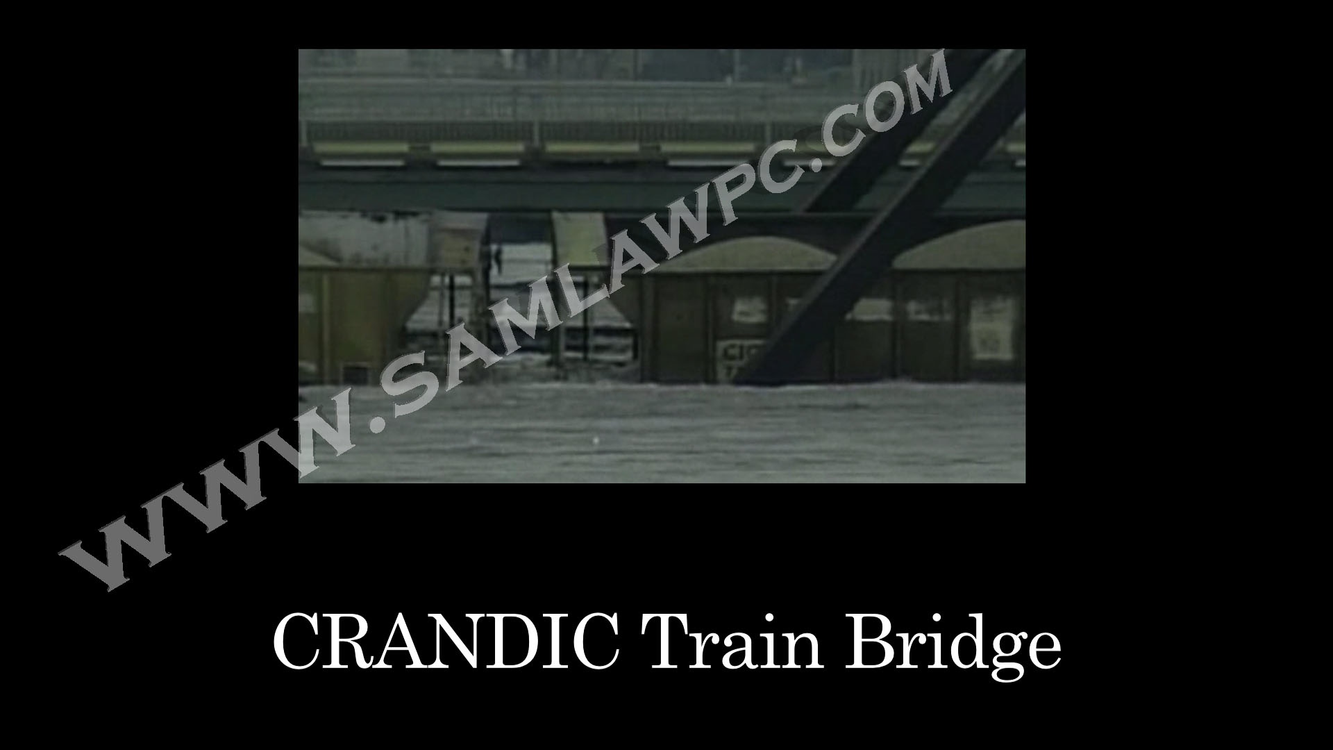
*June 13, 2008: The first rail bridge, Alliant Energy/CRANDIC’s rail bridge near the Penford plant, collapses, dropping the volumetric equivalent of 120 semi-tractor trailers into the Cedar River, damming it.
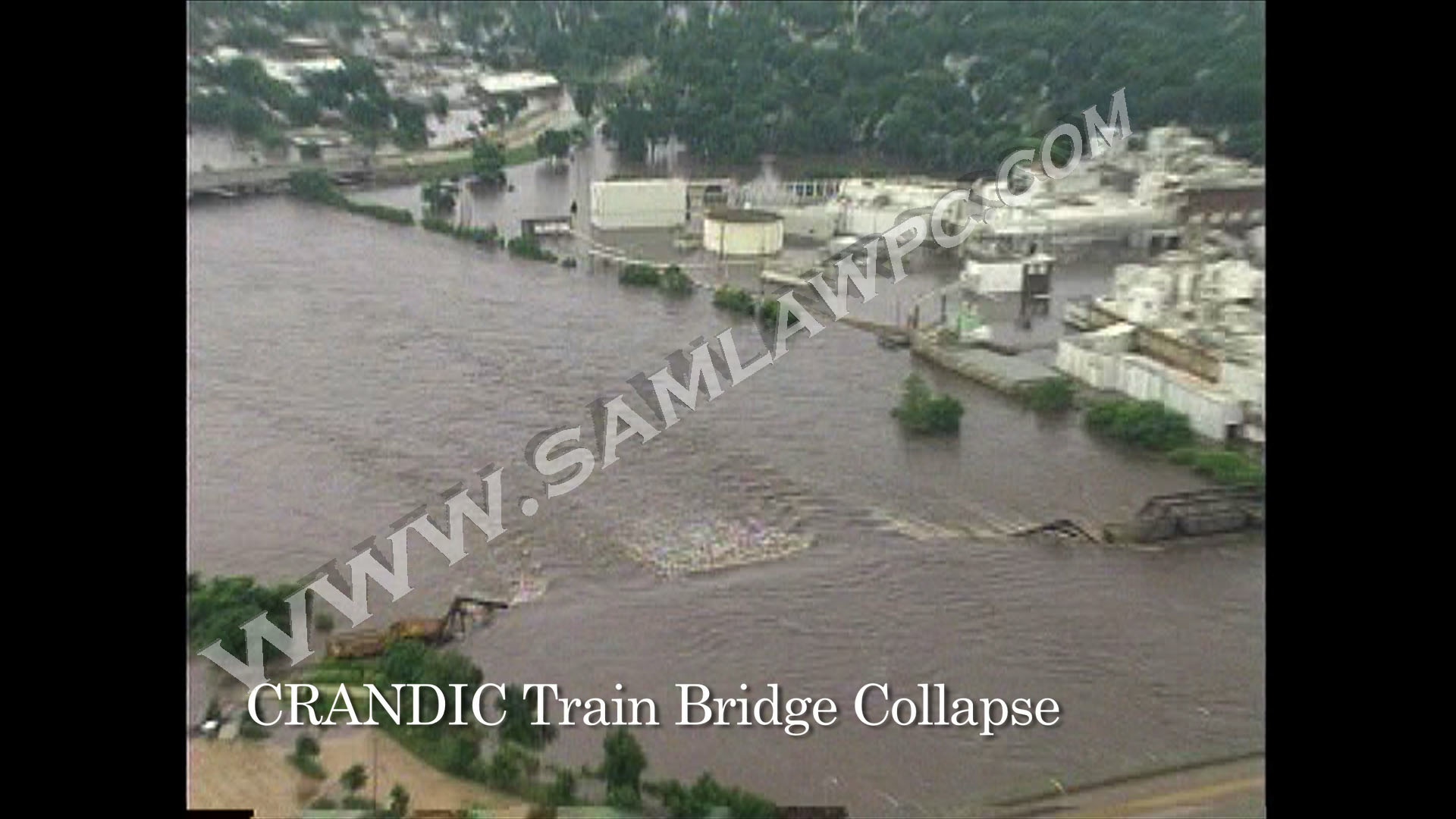
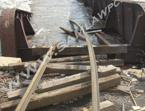
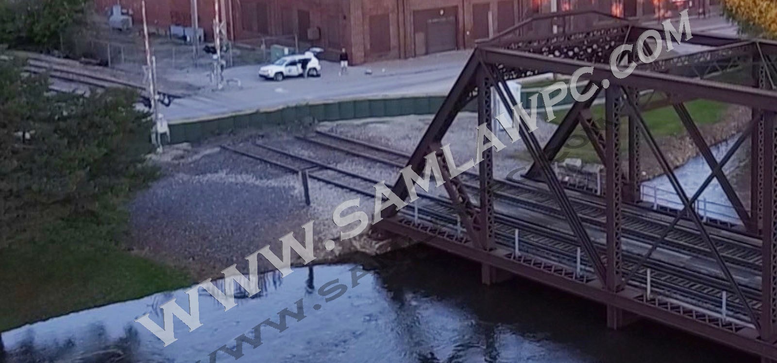
*June 13, 2008: The second rail bridge, jointly owned by Union Pacific and Alliant Energy/CRANDIC, collapses into the Cedar River near the Cargill plant; rail cars were not placed on this bridge as Defendants had abandoned it in 1980; this bridge had 9.5 foot solid sides.
June 16, 2008 photo of Union Pacific’s and Alliant Energy/CRANDIC’s rail bridge near Cargill in the foreground near the bottom of the photo as the water is receding; note green vegetation growing on remains of abandoned rail bridge with 9.5 foot iron sides.
Until UP and CRANDIC took the steps described above and as alleged in the Plaintiffs’ Class Action Petition, Cedar Rapids was experiencing a fairly typical, minor flood causing no property damage. After the rail bridges collapsed, however, the river suddenly shot up 9.36 feet. The height of the rail cars that collapsed into the river are 9.4 feet while the height of the solid-sided Cargill Plant Bridge (owned by UP and CRANDIC) is 9.5 feet. Plaintiffs contend this is not a coincidence.
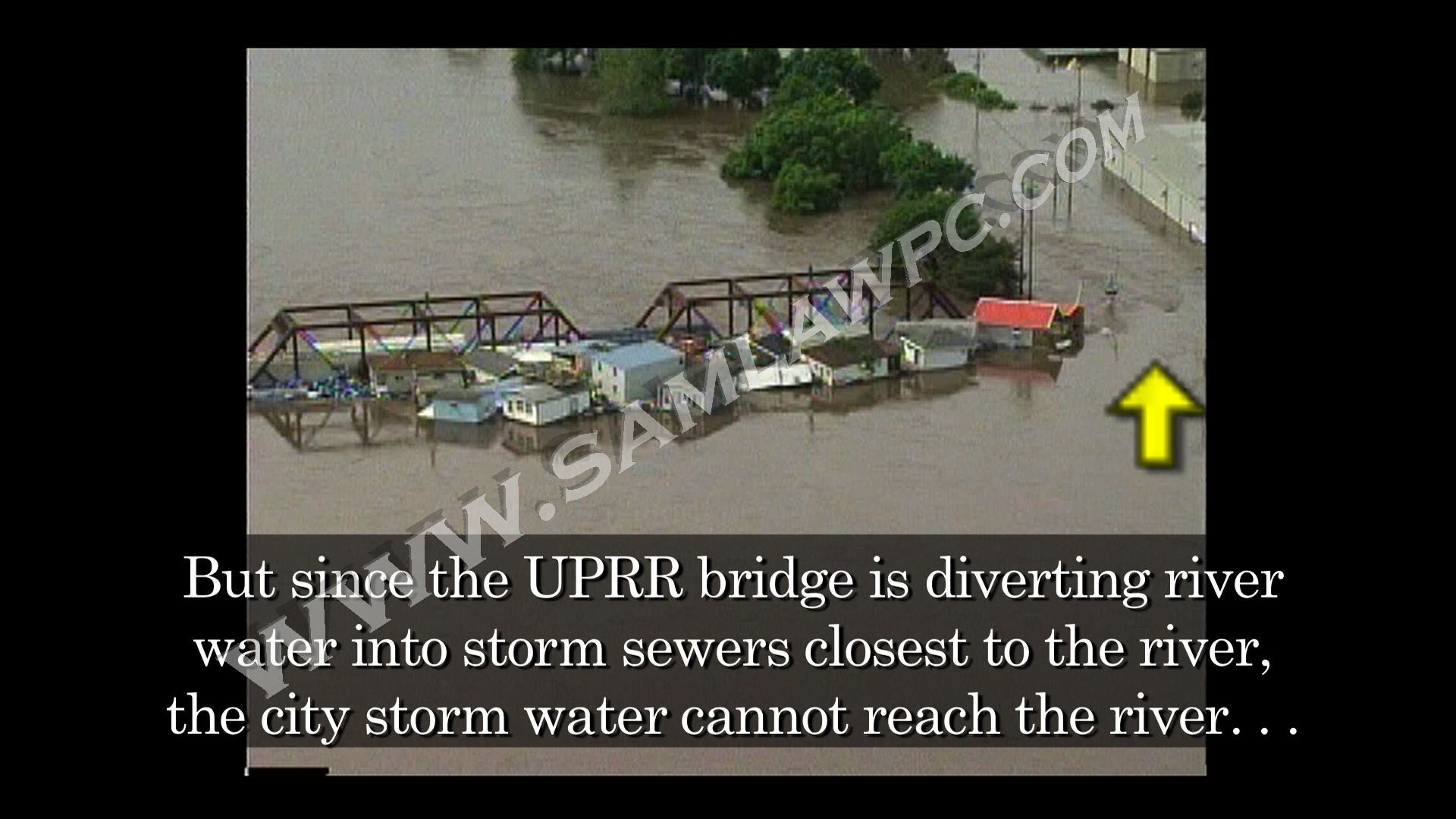
As indicated in the USGS hydrograph below, on September 27, 2016, the Cedar River in Cedar Rapids reached a crest of 21.97 feet, 2.1 feet higher than the 2008 height of the Cedar River immediately before UP and CRANDIC’s rail bridges–carrying joined rail cars filled with rock–collapsed into the river. But in 2016 there was no property damage because the City blocked Union Pacific Alliant Energy/CRANDIC from parking their rail cars on their bridges in 2016.
Stated another way, the crest of the 2008 Flood (31.12 feet as indicated in the USGS hydrograph below) minus the crest of the 2016 Flood (21.97 feet) is 9.15 feet. The height of the UP and CRANDIC rail cars that collapsed into the river in 2008 were 9.4 feet, and the solid-sided rail bridge which collapsed (“Cargill Bridge” in the Class Action Petition) in 2008 was 9.5 feet. Plaintiffs’ Counsel look forward to proving at trial that Union Pacific and Alliant Energy/CRANDIC significantly exacerbated an otherwise minor flood in 2008.
The USGS hydrograph below confirms that the river reached 21.9 feet during the September 27, 2016 “flood” which is 2.1 feet higher than the river at the time the Defendants’ railroad bridges collapsed in 2008:
Hydrograph of 2008 Flood in Cedar Rapids; Cedar River at 19.87 feet before Defendants rail bridges collapsed in 2008:
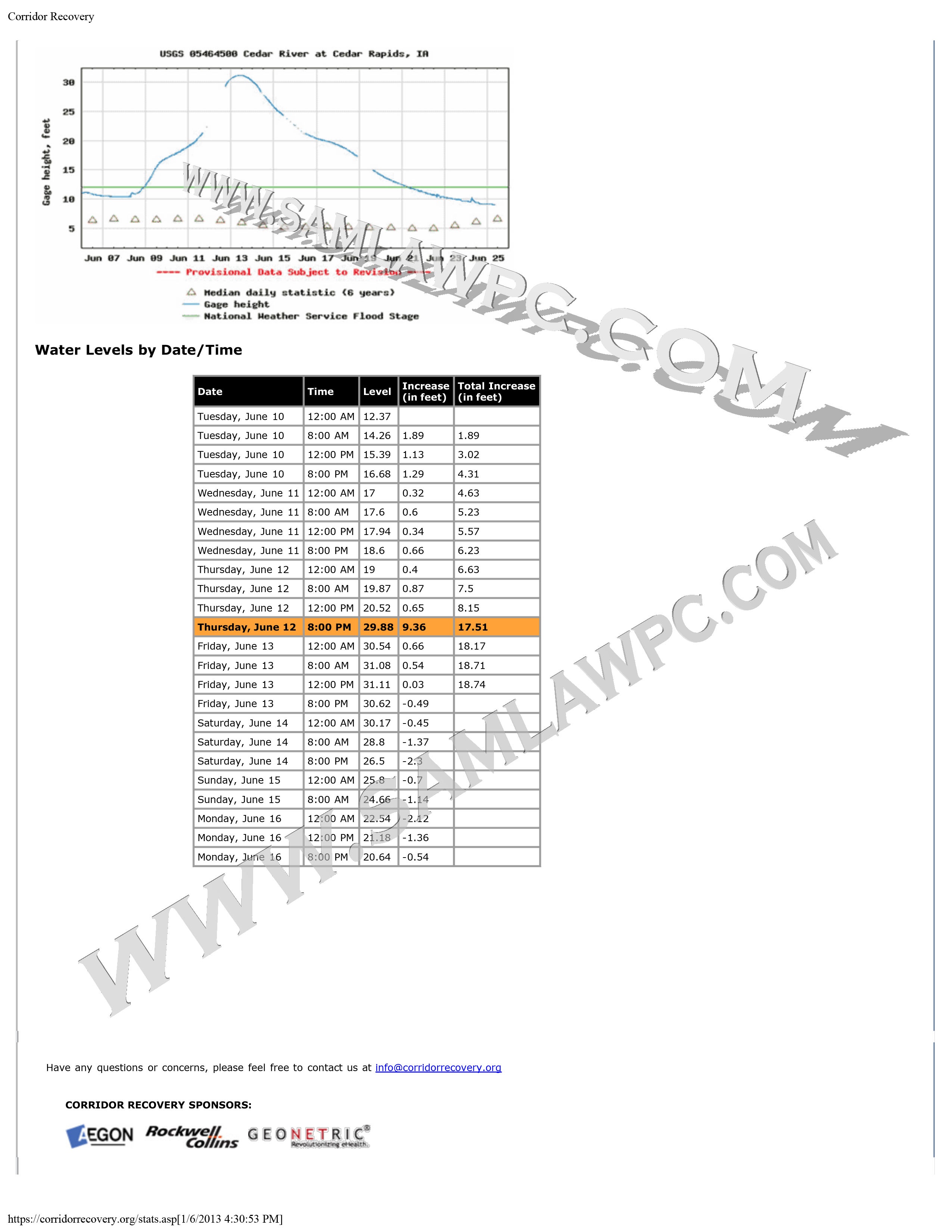
The 2008 Flood table and hydrograph above from the USGS website has been reproduced below to illustrate the effect of the collapsing bridges.
The difference: In 2016, the City of Cedar Rapids exercised its police power by using HESCO sand-filled barriers to block Union Pacific and Alliant Energy/CRANDIC from accessing all of their rail bridges in 2016 resulting in no collapsed bridges and no flood causing property damage in 2016 despite the river being 2.1 feet higher in 2016 than at the time the rail bridges collapsed in 2008.
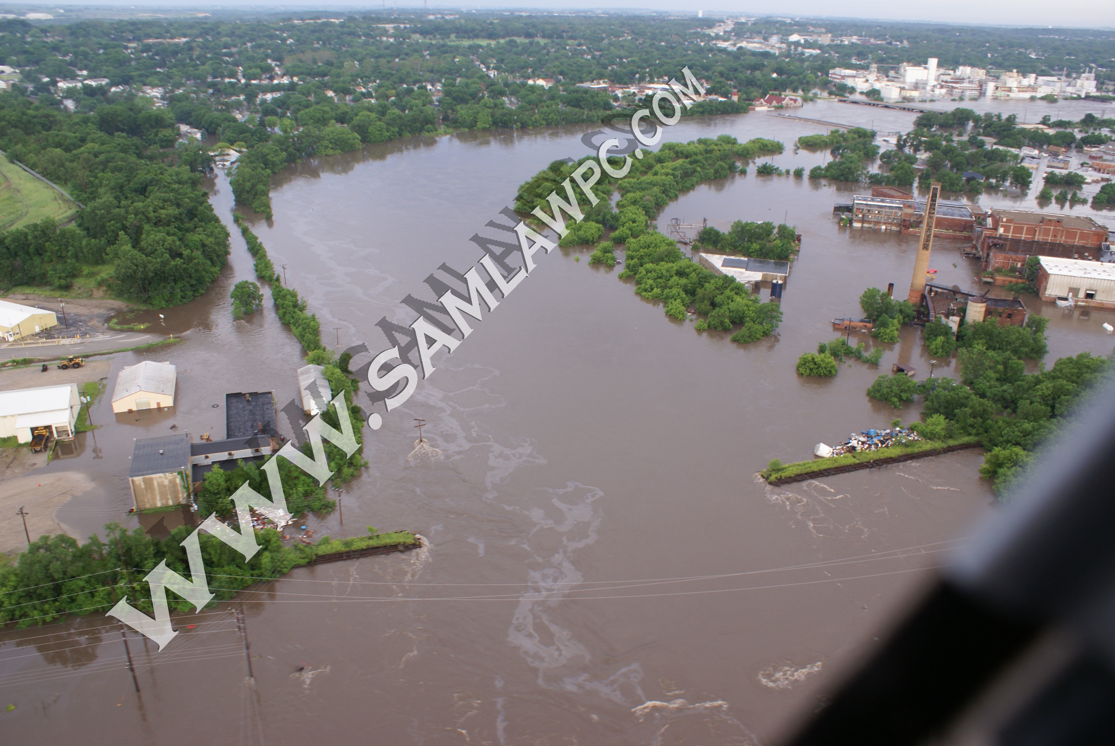
In this September 27, 2016 photo taken at the time the river crested at 21.9 feet–2.1 feet higher than the level of the river at the time Union Pacific’s and Alliant Energy/CRANDIC’s collapsed into the river in 2008–the City of Cedar Rapids exercised its police powers to protect public safety by blocking both ends of all of Defendants’ rail bridges with the green and tan HESCO sand-filled barriers; note that river is no where spilling over its banks in photo above despite the river being 2.1 feet higher in the photo above than the river level at the time the Defendants’ rail bridges collapsed in 2008.
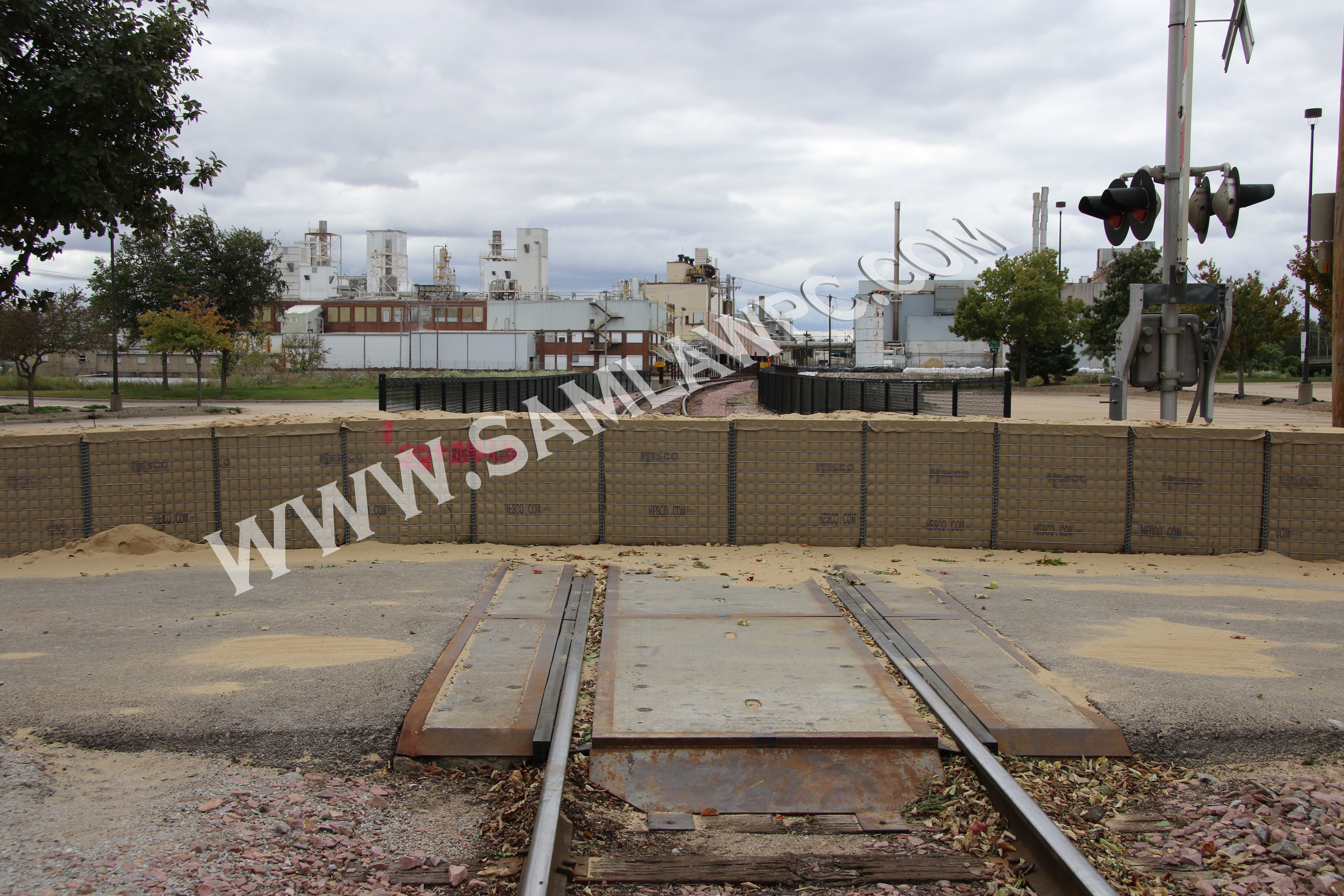
September 27, 2016 photo showing City blocked access to all of Defendants’ rail bridges ahead of a minor flood so that Defendants could not park their rail cars on them including the Alliant Energy/CRANDIC rail bridge near the Penford plant in the photo above.
In our next blog post/press release, we’ll explain why Eastern Iowa was flooded in 2008 by three man-made obstructions/disasters and not by “excessive rain.” Click here to see the next blog post/press release.
###
Given the sheer number of people affected by the 2008 Flood, if you have information about the 2008 Flood you think we should know, or if you would like to be a potential class representative, please do not call or stop by our office, but rather, please click on our contact page here for further information.